GeoRank
GeoRank is the only tool that ranks every place on earth by crypto CGT, letting you pin, compare, and ask AI about your relocation shortlist.
VisitPublished on:
July 13, 2026
Pricing:
About GeoRank
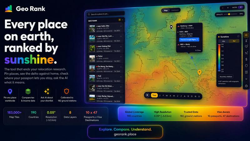
GeoRank is a free, no-signup interactive map that consolidates every critical data point you need to decide where to live next into a single decision tool. Instead of juggling a dozen open tabs between weather sites, Numbeo, embassy pages, and nomad forums that never talk to each other, GeoRank layers eight distinct datasets over a global grid of approximately 5-kilometer cells. This includes sunshine and temperature data calibrated against 182 ground stations using SARAH-3 satellite observations, ERA5 reanalysis, and CHELSA climate models, as well as tax rates from OECD, PwC, and KPMG. It also covers per-passport visa and residency routes across 47 destinations for 10 different passports, cost-of-living data from 478 cities, geopolitical risk scores, and a community-sourced "Nomad Pulse" sentiment tracker. You can pin your candidate places, switch to Compare mode to see every metric as a delta against your current home (warmer, cheaper, safer, taxed differently), and ask an AI assistant that reasons only over your own shortlist. GeoRank is built for the actual decision of where to relocate or spend an extended stay abroad, not just for browsing data. It is opinionated, curatorial, and designed to replace endless research with one definitive answer.
Features of GeoRank
Explore Globally with 9 Live Layers
Toggle between nine live data layers on the map, including sunshine, temperature, rainfall, outdoor hours, taxes, visas and residency, cost of living, geopolitical risk, and nomad sentiment. You can pan globally and zoom down to approximately 5-kilometer cells, giving you a granular view of any location on earth. Each layer is a live data source you can switch on or off, and clicking any layer reveals its specific methodology and accuracy metrics.
Pin and Compare Against Home
Click any location to pin it to your shortlist, with support for up to 20 places saved across browser sessions. When you switch to Compare mode, you set your current home as a baseline, and every pinned location shows a delta against that baseline. You instantly see how many more sunshine hours, how much cheaper, how much safer, or how differently taxed each place is compared to where you live now, turning absolute numbers into relative, actionable insights.
Chat Your Shortlist with AI
The AI assistant operates exclusively on your pinned locations, not on a generic knowledge base. You can ask questions like "Which of my 5 places has the best winter?" and it will reason across all your specific data points to deliver a cited, grounded answer. This feature bridges the gap between raw data tables and real-world decision-making, allowing you to explore tradeoffs, score locations by multiple criteria, and get personalized recommendations without leaving the map.
Calibrated Data, Not Raw Satellite Output
GeoRank does not use raw satellite data that often overestimates sunshine in cloudy regions. Instead, it merges SARAH-3 satellite observations with ERA5 reanalysis data, bias-corrected against 182 ground stations with orographic terrain corrections. This calibration covers locations from Reykjavik to Phoenix to Sydney, ensuring that the data you see is grounded in real-world measurements and accurate to within 8% for most locations.
Use Cases of GeoRank
Relocation Decision for Digital Nomads
A digital nomad on a UK passport is torn between Tbilisi and Paphos. They need at least 2,800 sunshine hours per year, low taxes, and visa-free access. Using GeoRank, they pin both locations, set their home base, and ask the AI. The AI reveals that Paphos meets the sunshine threshold (3,140 hours) while Tbilisi falls short (1,987 hours), but Tbilisi is considerably cheaper at $900 per month versus $1,600. The AI also notes that the UK passport allows 360 days visa-free in Tbilisi versus 90 out of 180 days in Paphos, giving the nomad a clear tradeoff to evaluate.
Comparing Family-Friendly Destinations
A family with children is considering a move abroad and wants to balance cost of living, safety, and outdoor hours. They pin five candidate cities, set their home location, and use Compare mode to see the delta for geopolitical risk, cost, and outdoor hours. They then ask the AI, "What are the tradeoffs between Paphos and Tbilisi for a family?" The AI reasons across the pinned data, highlighting that Paphos offers better infrastructure and EU access at a higher cost, while Tbilisi is cheaper but has fewer sunshine hours and different visa rules.
Retirement Planning Based on Tax and Climate
A retiree wants to maximize sunshine and minimize taxes. They pin several countries known for favorable tax regimes for foreign-sourced income, such as Cyprus, Georgia, and Panama. Using the tax layer from OECD and PwC data, they compare income tax rates and the sunshine layer calibrated against ground stations. The AI helps them score their shortlist by combining sunshine hours and tax rates, revealing which location offers the best balance for their specific financial and lifestyle needs.
Evaluating Geopolitical Risk Before a Long-Term Stay
A remote worker is considering a six-month stay in a region that has recently seen political instability. They use the geopolitical risk layer to compare their shortlisted cities, then ask the AI to rank them by safety. The AI provides a grounded answer based on the risk scores, and the user can cross-reference this with the Nomad Pulse sentiment data to see if the community is reporting rising or falling enthusiasm in those areas. This helps them avoid locations where risk is escalating.
Frequently Asked Questions
How does GeoRank ensure its data is accurate and not just raw satellite estimates?
GeoRank calibrates its data against ground truth. For sunshine and temperature, it merges SARAH-3 satellite observations with ERA5 reanalysis data and bias-corrects the results against 182 ground stations located in diverse climates from Reykjavik to Phoenix to Sydney. This process includes orographic terrain corrections, ensuring that high-altitude locations and coastal microclimates are represented accurately, with a typical accuracy of plus or minus 8% for most locations.
Do I need to create an account or pay to use GeoRank?
No, GeoRank is completely free and requires no signup. You can access the interactive map, toggle all nine data layers, pin up to 20 locations, use Compare mode, and ask the AI assistant without creating an account or providing any personal information. The tool is designed to be immediately usable for anyone researching relocation or extended stays abroad.
How does the AI assistant know about my specific pinned locations?
The AI assistant operates exclusively on your pinned locations and their associated data from GeoRank. It does not access a generic knowledge base or the broader internet. When you ask a question like "Which of my 5 places has the best winter?", it reasons across the specific metrics for each of your pinned places, including sunshine hours, temperature, cost, tax, and visa rules, and provides a cited, grounded answer based solely on that data.
What data layers are available on the map, and how are they sourced?
GeoRank offers nine live data layers: Sunshine (from SARAH-3 satellite and ERA5), Temperature (from ERA5 and CHELSA), Rainfall (from CHELSA), Outdoor Hours (calculated from sunshine and temperature), Tax (from OECD, PwC, and KPMG), Visas and Residency (covering 47 destinations and 10 passports), Cost of Living (from 478 cities), Geopolitical Risk, and Nomad Pulse (community-sourced sentiment). Each layer has a methodology page that details its specific sources, coverage, and accuracy.
Similar to GeoRank


Memorable Contact
AI-powered relationship memory that helps you remember people, the context behind your connections, and reconnect when it matters.

Video Text Remover
Video Text Remover — Erase Subtitles & Watermark from Video