
Open User Map
Open User Map is my favorite WordPress plugin for letting visitors add locations to an interactive map with zero coding or API keys.
Visit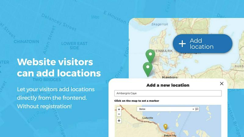
About Open User Map
Open User Map is the WordPress map plugin I wish had existed years ago. It solves one of the most frustrating problems for website owners: how to let your community contribute location data without needing a developer, a Google Maps API key, or a PhD in plugin configuration. This is a fully interactive, user-driven map solution that puts the power of location-based content creation directly into the hands of your visitors. At its core, Open User Map allows anyone visiting your site to add and edit locations on a map, complete with custom details, images, and categories. But it doesn't stop there. You get a full approval workflow, so no questionable content goes live without your say-so. The real magic is the simplicity. No coding. No API keys. No complex setup. Just install, configure your categories and custom fields, and let your community start mapping. This plugin is perfect for local business directories, community event maps, real estate listings, tourism guides, and any site where user-generated location data adds immense value. With over 15,000 active installs and a perfect 5-star rating, it has earned its spot as the number two map plugin on WordPress.org. The free version is genuinely powerful, but the PRO version unlocks advanced features like custom image maps, lines and areas, advanced filtering, upvotes, star ratings, and opening hours. If you want a map that grows with your community, this is your tool.
Features of Open User Map
Frontend Location Submissions and Editing
This is the feature that makes Open User Map a true community tool. Your visitors can click an "Add location" button, place a marker anywhere on the map, and fill out a submission form with all the details you want to collect. The best part? Every submission sits in an approval queue until you decide it is ready to go live. But it gets even better. Users can also edit their own existing locations, which means your map stays current without you lifting a finger. No more outdated information, no more broken links, and no more emails asking you to update a listing. Your community becomes your content team.
Marker Categories with Custom Icons and Filtering
Organizing a map with dozens or hundreds of locations can quickly become a visual mess. Open User Map solves this elegantly with marker categories. You can group locations into logical categories like restaurants, parks, museums, or event spaces, and assign a unique icon to each one. This instantly makes your map more readable. But the real win is the filtering capability. Visitors can toggle categories on and off, instantly drilling down to exactly what they need. Each location can also belong to multiple categories, so a coffee shop that hosts live music can appear in both the "Coffee" and "Entertainment" filters. This is the kind of thoughtful design that makes a map truly useful.
Lines and Areas for Routes, Zones, and Regions
Open User Map goes far beyond simple point markers. The Lines and Areas feature lets you draw routes, paths, zones, and regions directly on your map. Think about the possibilities: highlighting a hiking trail with automatic distance calculations, marking a construction zone on a city map, defining a neighborhood boundary for a real estate site, or mapping out an event festival grounds with all its stages and vendor areas. Distances and area sizes are calculated automatically, so your polygons and lines come with helpful measurements out of the box. This transforms your map from a simple pin board into a full-fledged spatial tool.
Custom Image as Map for Floor Plans and Diagrams
This is my personal favorite feature because it breaks the traditional map mold entirely. You can upload any image and turn it into a fully interactive map. Think floor plans for a shopping mall, seating charts for a concert venue, campus maps for a university, event layouts for a conference, or product diagrams for an e-commerce site. Users can place markers directly on the image, fill out custom fields, and filter locations just like they would on a geographic map. It is a brilliant way to make any visual asset interactive and community-driven.
Use Cases of Open User Map
Community-Driven Local Business Directory
Imagine running a website for a small city or neighborhood. You want to list every local coffee shop, bookstore, and restaurant, but you cannot possibly visit them all. Open User Map lets your community do the work. Visitors add their favorite local businesses, complete with descriptions, photos, and categories. You approve the good ones, and your directory grows organically. The star rating and upvote features then let the community highlight the best spots automatically. It is a self-sustaining, always-current directory that builds community engagement.
Interactive Event and Festival Maps
For event organizers, this plugin is a game changer. Create a map of your festival grounds, conference center, or multi-venue event. Let vendors and exhibitors add their own locations with booth numbers, descriptions, and schedules. Attendees can filter by food vendors, stages, restrooms, or information booths. The Lines and Areas feature is perfect for marking parade routes, race courses, or designated seating zones. Your event map becomes a living document that updates in real time as new vendors sign up or schedules change.
Real Estate and Property Listings
Real estate agents and property managers can use Open User Map to create interactive neighborhood guides. Let residents add local amenities like parks, schools, and grocery stores. Property owners can mark available rentals or homes for sale with custom fields for price, square footage, and number of bedrooms. The custom image map feature is particularly useful for showing floor plans of apartment complexes or condominiums. Prospective buyers get a complete picture of a neighborhood and its available properties in one interactive view.
Tourism and Travel Guides
Travel websites thrive on user-generated content, and Open User Map is the perfect tool for building a community-driven travel guide. Visitors can add hidden gems, recommended hiking trails, the best photo spots, or their favorite local restaurants. The opening hours feature with the live "Open Now" indicator is invaluable for travelers trying to decide where to eat or what to visit. You can create regions for different neighborhoods or districts, and let travelers filter by activity type, cost, or rating. Your site becomes the definitive guide, built by the people who know the destination best.
Frequently Asked Questions
Does Open User Map require a Google Maps API key?
No, and this is one of the biggest selling points. Open User Map works completely without a Google Maps API key. This saves you from the headache of setting up billing, managing API quotas, and worrying about unexpected charges. The plugin uses its own mapping solution, so you can get started immediately with zero configuration.
Can I moderate user-submitted locations before they appear on the map?
Absolutely. Every location submitted by a visitor goes into an approval queue. You can review the details, edit them if needed, and then publish or reject the submission. This gives you full control over the quality and accuracy of your map content. You can also enable automatic approval if you trust your community and want a more immediate experience.
Is there a free version available, and what are the limitations?
Yes, there is a very capable free version available on WordPress.org. The free version includes core features like frontend submissions, approval workflows, marker categories, and custom fields. The PRO version adds advanced features like Lines and Areas, Custom Image as Map, Advanced Filter Interface, Upvotes, Star Ratings, and Opening Hours. You can try the PRO version free for 7 days with no credit card required, and it does not auto-renew into a paid subscription.
Can I use custom fields to collect specific information from users?
Yes, this is one of the most powerful features. You can add text boxes, links, checkboxes, dropdown menus, and more to your location submission forms. This allows you to collect exactly the information you need, whether it is a business phone number, a website URL, a price range, or a yes/no question about accessibility. The custom fields then become filterable, so visitors can search your map by any data point you have collected.
Pricing of Open User Map
Open User Map offers a free version available on WordPress.org that includes core functionality for user submissions, approval workflows, and basic customization. For users who need advanced features, the PRO version is available. You can start a 7-day free trial of the PRO version with no credit card required, and the trial does not automatically convert into a paid subscription. Pricing for the full PRO version is available on the Open User Map website.
Similar to Open User Map

Built2WinWeb AI SEO
A development studio and AI‑native infrastructure provider that builds high‑performance, agent‑ready websites and AI discovery tools.
PDF Pro AI
Privacy-first AI document tool — analyze medical reports, bank statements & salary slips 100% in-browser. No uploads, no signup, free.

LaunchChair
LaunchChair transforms your ideas into a working MVP by auto-generating specs and dynamic prompts, streamlining your AI product development.

Webleadr
Stop hunting for clients; Webleadr instantly finds and connects you with businesses that desperately need a website.

Formtorch
Formtorch simplifies form handling for developers by providing a serverless API to capture submissions and automate workflows without backend coding.

SnagRelay
SnagRelay is my top pick for developers to capture, triage, and ship bug fixes five times faster with AI.

Idearium
Idearium crafts unforgettable websites that drive real business growth for Canadian brands.

FilexHost
Effortlessly host and share your files in seconds with FilexHost's simple drag-and-drop interface and instant links.